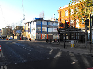
Fair enough, you might say: there's too much traffic jamming up the one-way system and generally making the town centre unfriendly to pedestrians, motorists and cyclists alike. Below is the bit Greenwich council wants to pedestrianise. It looks a pretty modest proposal: 0.16 miles (232 metres), of existing road given over to pedestrians. On the online consultation document this area is marked as ''Pedestrian area, residents and business access only,'' so cycling is not permitted.
But there's too much motorised traffic - where can it all go? I know, a gyratory system! Instead of a one-way system in central Greenwich that takes 0.28 miles (448 metres) to go round, they come up with a 2-lane gyratory one-way system which is 1.1 miles (1,774 metres) to get round.
In fact, for the first consultation exercise back in December 2009 there were a number of different proposals, such as keeping parts of it 2 way for buses, or putting in a cycle contraflow along Greenwich High Road. The aim of these hybrid plans was to undo some of the damage done to bus routes or to cycle routes.
I should perhaps say ''purported aim'' because the consultation document used out of date maps that actually removed all evidence of a well-used cycle and pedestrian route into Greenwich from Deptford in the east, namely, the Ha'penny Hatch. (The new amended consultation plan, detail below, still doesn't show the route. The Hatch bridges Deptford Creek between the two sets of railways where they split on the left.)
Where there's a box marked 4 on the map, the original proposal was to have a 2-lane one-way entrance into Norman Road by the North Pole pub, and all evidence of a cycle route had been removed. This proposal would have prevented cyclists getting from the Hatch to Greenwich High Road without first being sent north, i.e. completely the wrong direction. In addition, the proposal would have meant trying to force 2 lanes of right-turning traffic between these 2 buildings.
My own feeling when I saw this was that the mouth of Norman Road was not wide enough to allow 2 lanes of traffic into it and that, as it would have to be one lane, there would therefore be room to put a cycle lane. (Note that the lights have had to be set back on Norman Road because it's already too narrow for LGVs to turn into it.) I suggested this and was told a by a consultant that a cycle lane couldn't be done. Luckily, other people must have also raised this problem in the consultation, and they've since looked at the map and decided that it could be done. The green arrows on the amended consultation document indicate a cycle contra-flow, albeit on the wrong side of the road.
But much of that is a a very localised bit of history and unimportant in the grand gyratory scheme of things. Let's get back to the overall view. If we accept that life is unpleasant for pedestrians in central Greenwich, we're going to have to also accept that there are simply too many vehicles passing through Greenwich. One way of fixing this is to push traffic out of the way, displacing the problem. Another way is to encourage more people to use smaller, more fit-for-purpose means of transport. Which is where, ding ding, the bicycle comes in!
More people on bikes means fewer motorised vehicles on the streets. Sure, they have a slower top speed, but they're smaller, greener, and more flexible than motorised vehicles so that they can often be faster in busy urban environments.
Increasingly, there are more people getting on their bikes for the daily commute or for pleasure and exercise. On a good day, the commute, pleasure and exercise come together all in one. So let's look at these biking commuters - how do they get round Greenwich? And how would the proposed road changes affect their daily journey?
-0-
For the biking commuter heading into town from East Greenwich, Charlton, Woolwich - present in blue, shortest proposed route in red. Route from Trafalgar Road to Creek Road Bridge.Blue route 633 metres, red route 821 metres. Impact on cyclists: longer journey. Incentive to choose cycling: zero.
-0-
For the cyclist heading to Docklands via the Greenwich Foot Tunnel from Blackheath, Eltham, etc. Present route, blue. Shortest proposed route in red. Park gates to tunnel.Blue route 570 metres. Red route 1,349 metres. Impact on cyclists: journey length doubled. Incentive to choose cycling: zero.
-0-
For the cyclist heading to Docklands from Lewisham. South Street/Circus Street to Foot tunnel
Blue: current route (776 metres). Shortest route under proposals in red (1,564 metres). Impact on cyclists: an incredible doubling of distance. Incentive to choose cycling: zero.
-0-
And for me, heading toward the Coop/Somerfields to do a bit of shopping from Deptford. Ha'penny Hatch to Shop.
Blue route: 755 metres. Shortest possible proposed route:1,122 metres. Impact on cyclist: 67% longer journey. This additional distance will also affect all cyclists heading from the A2 at Deptford Bridge. Incentive to choose cycling: zero.
----0----
In fact, no cycling route is improved and many are made more lengthy. The plans will further inconvenience cyclists and it can only act as a deterrent for new cyclists to get out of their tin boxes and go smaller and greener. Deterring cycling is the last thing we need to alleviate the problem. Producing consultation maps that do not show current cycle facilities is also deeply misleading because it hides the true picture from the public.
And all for what? 232 metres of pedestrianisation. The plans are an object lesson in how not to design an integrated transport system. I will be making this point to TfL, cycling organisations such as CTC and, of course, to Greenwich Council to make very clear my opposition to this scheme. If the solution to too much traffic is making journeys longer for alternative transport then clearly they haven't understood a single thing.


